SODAVILLE HISTORY
In one of the most picturesque settings on the western slope of the Cascade Mountains is the little town of Sodaville where on the hillside overlooking the town and valley is the location of the famous Sodaville Mineral Springs. Incorporated in 1880, it officially became the City of Sodaville, Linn County, Oregon. The original intent was to incorporate earlier on and compete with the cities of Salem, Portland, Corvallis and Oregon City for State Capital, there was a land dispute (that was later settled by the Supreme Court) and Congress in Washington D.C. named Salem the capital.

The Soda Springs were discovered in 1848 by Reuben Coyle. The history of Sodaville centers around the spring of pungent mineral water flowing from a rocky hillside. For many years, the water from the spring was highly regarded for its medicinal purposes. People came from as far as Canada to collect or bathe in the soda water. It reached its height in the 1800’s boasting 5 hotels, livery stables, Perry Drug Store, a skating rink, a jail, bath houses, a general store, post office, meat market, barber, cobbler, blacksmith, daily stagecoach, weekly paper, doctor, telegraph office, 3 churches, furniture factory, sawmill, the Sodaville Railroad Company, and the Mineral Springs (Seminary) College that was founded in 1892. Tragically there was a large fire in 1894 that started in the Hardman hotel and it burned many of the buildings to the ground although quite a few homes, the general store and a church remain today.

A donation of land was transferred to the state in 1890 by Thomas Summers. Sodaville Springs (Mineral Spring Park) became Oregon’s first official state park. The Oregon’s Parks and Recreation website itself actually gives that honor to Sarah Helmick State Park, deeded in 1922. Either way, the land did have official state park status as of 1947, but has been back in Sodaville’s control as a city park since 1972.

Today the population is about 345 and there has been an increased interest in living in the small town atmosphere. Close to amenities available in the cities of Lebanon and Sweet Home, the large lots, wildlife, and surrounding forest, means the City of Sodaville’s population is always increasing.
File

The History of Sodaville Power Point

Download File
SODAVILLE'S FOUNDER
image-923130-836128-Rueben_Coyle-c51ce-6512b.gif
Reuben Stringer Coyle 
Founder of Sodaville
Born 1821 
Died 1888 

Linn County Commissioner 1854 - 1856, 1858
Linn County Delegate 1857
Committee for Military Affairs 1857

Reuben Stringer Coyle settled in Linn County and began farming a 640-acre donation land claim and founded the town of Sodaville.

In 1854 Coyle became a Linn County Commissioner serving in this position from 1854 to 1856 and again in 1858. With statehood imminent, he spent 1857 at Oregon's Constitutional Convention. The convention delivered the proposed state constitution on September 18, 1857, for approval by referendum. It passed, though with some further amendments added by popular vote, and Oregon was granted statehood on February 14, 1859.

He served as a Delegate from Linn County at the Constitutional Convention and served on the Committee for Military Affairs.

image-924294-during-about-coylesign-16790.jpg
Reuben Stringer Coyle was born in Bullitt County, Kentucky, in 1821. Family lore describes him as a "Man of Enterprise" with "movin' on" in his blood. The Coyles moved to Peoria County, Illinois, when Reuben was a young man, and there he met and courted Hannah Carroll. They were married May 16, 1843, and had two children, two year old Thomas Jefferson Coyle and four month old John Henry Coyle when they emigrated to the Oregon Country in 1847. Accompanying the family were Hannah's brother and father and one of Reuben's brothers.

Among the belongings which Reuben and Hannah packed away for the journey was a newly minted $10 gold coin. The coin was Reuben's measure of last resort, to be used only in the event of the family being reduced to utter poverty and desperation. It survived the journey to Oregon and was passed down through four generations of the Coyle family spanning 130 years, always with the understanding that it was not to be spent unless all else failed. Its last family recipient, Oda Coyle Hudson, was a widow with no children, and thus the coin was entrusted to the Oregon Historical Society in 1977.

After arriving in Oregon, the Coyles claimed 640 acres of land in Linn County southeast of Albany and began farming. Reuben later platted and developed the town of Sodaville, named for nearby mineral springs, after Claim 4847 was perfected under the Donation Land Act of 1850. Modern residents believe that a handful of ancient fruit trees located within the bounds of the original family claim were saplings planted by Reuben himself in the 1840s.

While the Carrolls headed south to cash in on the California gold rush in early 1849, Reuben apparently remained in Oregon with Hannah and the children. Reuben went into politics in the 1850s. The Carrolls didn't strike it rich, but they didn't go bust, either, before returning to the Willamette Valley when the '49ers began pouring into California that fall.

Along with one of his sons, Reuben finally headed south to California following rumors of gold strikes in the 1860s. He is known to have returned home at least once following some modest success in the gold fields, but the family eventually lost track of him.
He is believed to have died in January, 1888, but it is not known where he was buried. Hannah died on March 30, 1870, at the age of 45. Until the 1980s, six generations later, there were still descendants of Reuben and Hannah Coyle to be found living on part of the old family claim.
THE EARLY YEARS OF SODAVILLE
MINERAL SPRINGS ACADEMY
History of Sodaville Schools

Sodaville School District bears the number 13, signifying that it was the thirteenth district to be organized in Linn County. The first schoolhouse of which there seems to be any record was a log cabin situated a little north of west and across the road from the present (1937) school building. Of this schoolhouse a writer says: In the year 1851 Sodaville could boast of having the second best school in the county. A little one-room log schoolhouse stood on the hill where Mr. Chas. Snyder's house is located. It was built of green timber with the holes between the logs filled with mud and clay. The seats were split logs, round beneath and flat on top, with pegs nailed in the ends and legs. A stone fireplace which served for heater and ventilator, was built in one side. A water bucket of sodawater was kept constantly on hand. Whenever the supply ran low a couple of small boys were sent to the spring for more.

The second schoolhouse was a one-roomed "box" building erected on the hillside in block 12, just southeast of the spring block. The date of its erection is not known, but in 1894 this building was divided by a partition into two rooms to accommodate the growing school. A short time thereafter it was enlarged by the addition of an L. This enlarged building was used for school purposes until 1909. In that year the district purchased the vacant building in the abandoned Mineral Springs College. Thereafter to the present date the old College has been used for public school purposes.

Grade school, only, has been maintained in the Sodaville district except during the years 1909 and 1914--17 when a high school was attempted for a limited time.

Mineral Springs Seminary at Sodaville was founded and its building erected by Lewis Barzee and his brother Charles in 1892. Lewis Barzee was first employed as a teacher in the district school, but after the expiration of his contract he remained in Sodaville for the purpose of establishing a seminary. This seminary he conducted successfully during the school seasons of 1892-93, after which the institution passed into the hands of the Cumberland Presbyterian Church and was reorganized under the name of Mineral Springs College, with Professor Jos. R. Geddis as president. The college was conducted under church management from 1893 to 1902 when, due to competition of other institutions of learning, especially the nearby Albany College, it suspended. About 1909 it again reopened under private management - that is, an association of men headed by Hubbard Bryant of Albany - but to no avail. During the same year the building and grounds were bought by Sodaville School District, No. 13, and was used for public school purposes. Mineral Springs Seminary has since then been torn down.

The college dormitory building was purchased by the local branch of the Patrons of Husbandry, moved three miles across country, and is now known as Crowfoot Grange Hall.

This historical piece was compiled by Workers of the Writer's Program of the Work Projects Administration In the State of Oregon, Sponsored by the Linn County Pioneer Memorial Association, Published about 1945. SOURCE
THE SPRING HOUSE
SODAVILLE SPRINGS HISTORIC STATE PARK
Sodaville Springs State Park

Sodaville Springs State Park is located in the town of Sodaville, being all of Block 8 on the east side of County Road 31 in Linn County. The State Highway Commission obtained the land from the Board of Control by Legislative Joint Resolution #6. The deed is dated January 20, 1947. The property was first dedicated for perpetual public use on May 4, 1871, by Thomas Summers. The Legislature granted a charter in 1880 to the town of Sodaville and gave its three trustees authority to take possession of Block 8 containing a soda mineral spring. The State Board of Control assumed jurisdiction over the park in 1890 and managed it through committees appointed by the Governor. From time to time the Legislature appropriated funds in sums ranging from $500 to $2,000 for the perpetuation, improvement and maintenance of the area containing the public soda mineral spring. A square building with multiple floors was constructed over the spring in the year 1891. The lower floor is open-sided and at an elevation where water from the soda spring can be obtained by gravity flow. The town of Sodaville was built around the mineral spring. Many visitors came to enjoy the therapeutic values of the water which they believed to be the elixir of life. Patronage was at its height in the 1890's, when, we are told, there were two hotels in the town and camping places were at a premium. People came from far and near and many made regular pilgrimages to drink the health-giving water. Years ago when the town was dedicated, the area was named Sodaville Springs and the park has carried that title since that date. The one block of land, containing one acre, slopes upward toward the east. It is covered with grass and a few trees are growing thereon. A plaque honoring Thomas S. Summers was erected on the north side of the building in 1926. The building has been used as the town office and by women's organizations and other group gatherings. Visitors to the area in 1962 totaled 5,638. No count was made in 1963.
The following permits affect the area: 1479 9-14-53 Sodaville—use of upper floor of bldg. Revocable SOURCE

The current Sodaville City Hall sits in the Sodaville Springs State Park in the exact place of the original Spring House. The cistern for soda water sets underneath it and is located at the north side of the building. Due to contamination in the early 1900's, the spring has been closed down permanently.
File

House Communication and Recorder's Certificate of donation of land from Thomas Summers on May 4th, 1871. Mineral Springs Park and Soda Water of said block No. 8, 1891 Senate Journal, pages 204-205.

Download File
SODAVILLE'S HISTORIC CHURCHES
The first Baptist congregation in Linn County was organized at Soda Springs (Sodaville) in the summer of 1848, with six members, by Rev. H. Johnson. Its records are lost, but it is known that the church came into the Willamette Association in 1850, reporting 11 members. There was a revival in 1853 under Rev. Ezra Fisher and William Sperry and 50 joined. However, 34 members were dismissed to organize the Pleasant Butte Baptist Church (now Brownsville), leaving 34 members. At the Association in 1854 it reported its prospects bright, but the prosperity was brief. Removals were frequent. Perhaps a more serious cause of decadence was that several of the more active members went with Ezra Fisher who, about 1857-58, organized a new church which would not co-operate with the other Baptist churches of Oregon on account of the slavery question. The church was thus left weak, with no pastor. It was represented in the Association until 1857, then became extinct. SOURCE


SODAVILLE'S HISTORIC COUNTRY STORE
image-388064-Sodaville03.jpg
HO Railroad piece depicting original Country Store
image-388065-Sodaville15B.jpg
HO Railroad piece depicting original Country Store
image-388060-b5f35cd9e34f1a1b27b2848999c437cf.jpg
The Original Country Store & Fueling Station, owned by the City of Sodaville is a project waiting to be refurbished. The City of Sodaville City Council and the Citizens Planning Committee are currently working on ideas for the store including rehabilitating it for a new City Hall & Community Center.
image-850642-1945_Sodaville_Cash_Grocery_Calendar_Website-8f14e.w640.jpg
1945 calendar from the
Sodaville Cash Grocery,
given to City of Sodaville
by Tracy Towry
HISTORIC SODAVILLE MAP'S
SODAVILLE CEMETERIES
KLUM B 0.62 2 1865 T12S R1W 832 

Located 1.4 miles southeast of Sodaville on Sodaville-Waterloo Drive. Turn south on Buckmaster Road from Sodaville-Waterloo Drive and go about 0.15 of a mile. The cemetery is 750 feet up the hill on the driveway to the left. It is on the William Klum D.L.C. #40, OC #3336.
 
NOTE: This site is on private property.
CHILDS A 0.9 5 1895-1905 T128 R2W 836

Located on the old Skeels Place west of Sodaville. From Sodaville, go west 0.4 of a mile on Sodaville Cutoff Road. Turn left (south) on Middle Ridge Drive and cross Oak Creek; at 1 mile from the starting point is a 90 degree turn to the right (south). Do not turn, but continue ahead on a lane 400 feet to a house. Then turn right and go another 800 feet. The cemetery is in open country to the right. There are 3 known graves on the Richard Usher D.L.C. #62, OC #4733.
​​​​​​​
NOTE: This site is on private property.
THOMPSON A 0.01 ? Nov 1888 T13S R1W S18

Located in the southwest 1/4 of Section 18. A single grave and stone on the old Sam Gunderson Place, about 4 miles south of Sodaville. The 1930 Metsker Land Ownership Atlas shows the Samuel Gunderson property on both sides of the Sodaville-Mountain Home Road. The 1936 ODOT map of Linn County shows the farm house on the west side of the road. Exact location unknown.
​​​​​​​
NOTE: This site is on private property.
SODAVILLE'S HAUNTED OR NOT!!​​​​​​​
image-923943-Andrew_Hale_Ghost_House_1-8f14e.PNG
image-923944-Andrew_Hale_Ghost_House_2-d3d94.w640.PNG
image-923945-Andrew_Hale_Ghost_House_3-6512b.jpg
image-923946-Andrew_Hale_Ghost_House_4-9bf31.jpg
image-923947-Andrew_Hale_Ghost_House_5-aab32.jpg
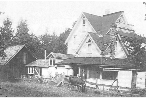
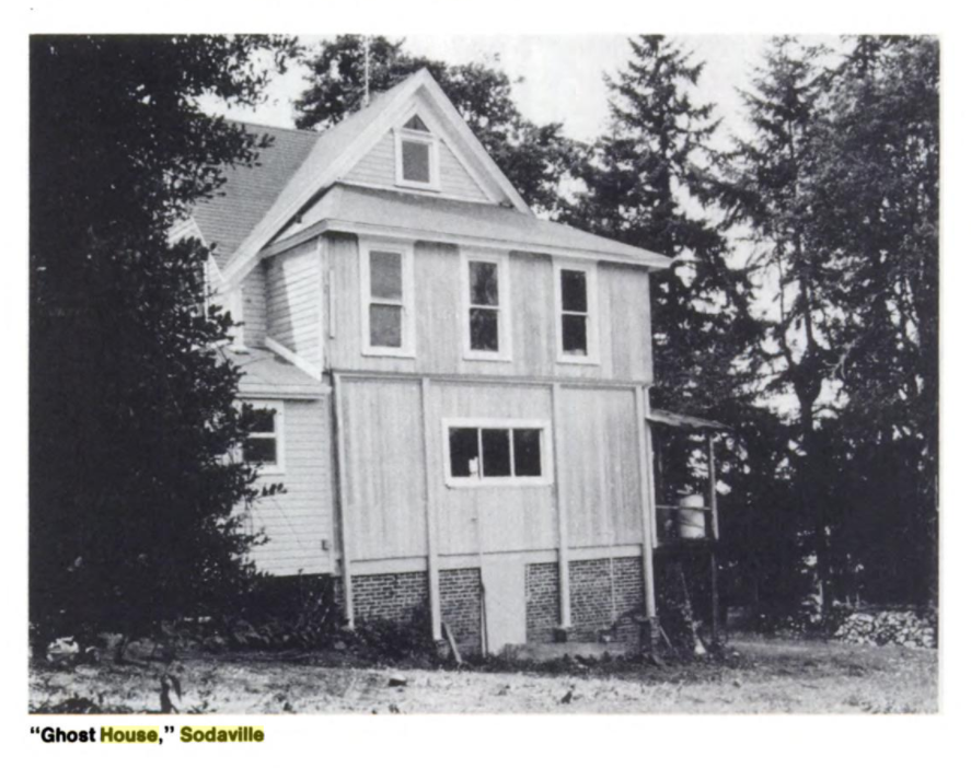
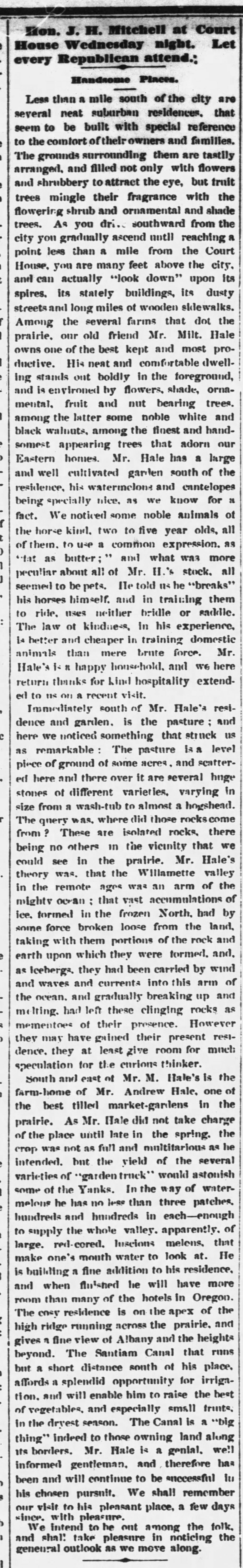
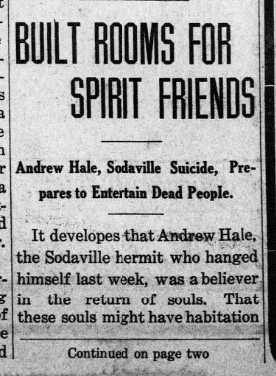
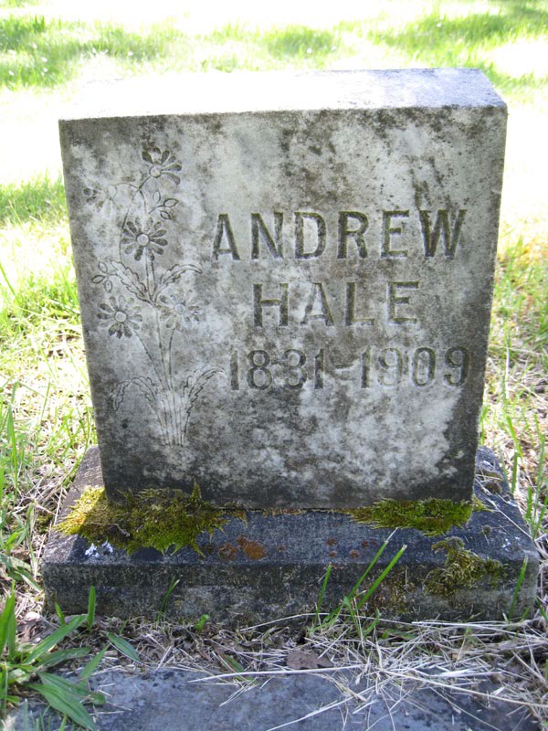
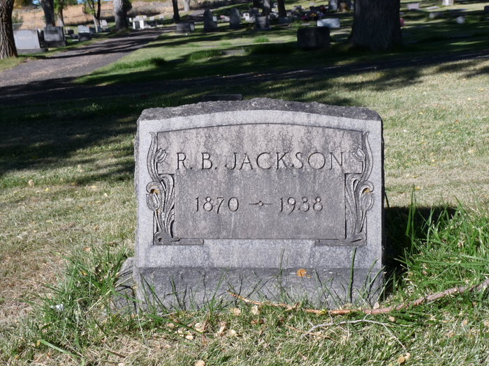
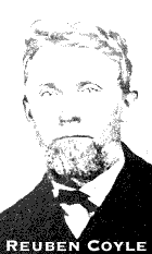
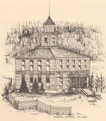
THE FAMOUS ANDREW HALE HOUSE... HAUNTED OR NOT??

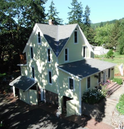
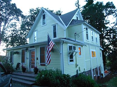
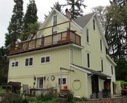
The house that Hale built, as the 'spirits' moved him.  A "haunted house" built before the turn of the century on the south side of Sodaville, still stands as a substantial memorial to its creator, a man named Andrew Hale,  a Sodaville hermit. The weather-beaten structure stands three stories high on a solid brick foundation. The house included an exit on the first floor level opening into thin air with no railing, no steps, nothing but a drop to a cement walk below. Another exit was built on the second floor with a 10 foot drop, according to Mrs. Alma Parrish, who chronicled much of  Sodaville's colorful history before her death.

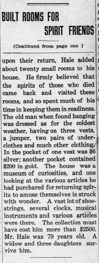
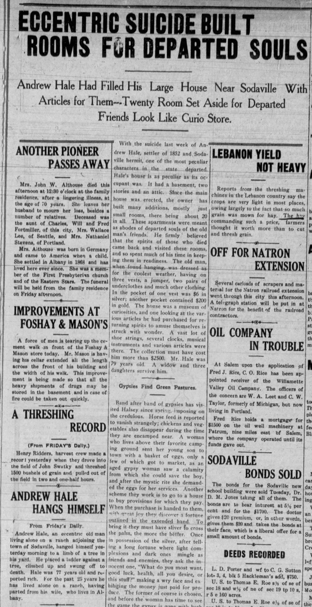
The house was labeled "Crazy House" and "Haunted" because of the mental aberration of the builder, whose imagination peopled it with innumerable spirits. Hale had a collection of perforated disks of familiar old time music and often at night he would put a lighted lamp in every window of his large house, then step out on to a grilled platform, off the attic level of his home and grind out music for the entertainment of his spirit guests.

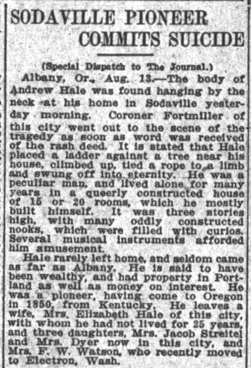
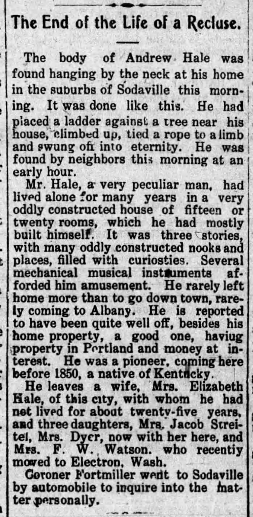
Although Hale's wife and family found it "impossible to live with him", according to Mrs. Parrish, his Sodaville neighbors regarded him as "eccentric but harmless". They may have laughed at him sometimes, but never feared him. Housewives, thinking of his lonely life, would supply him with pans of biscuits, pies and other home-cooked fare. In turn, Hale was fond of children, and if they took a shortcut to school through his property, he would fill their coat pockets with apples, even tying knots in their sleeves and filling them, too. Finally, wrote Mrs. Parrish, the nights became such a horror for Hale that he quietly hung himself in a tree on his property. The "spook tree" has since been cut down to a stump, but the day before his death, the spiritualist thoughtfully returned each empty pan, plate or dish to its owner.

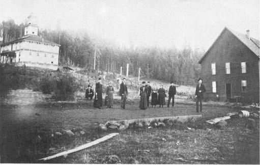
Mrs. C.F. Snider told Mrs. Parrish of her visit to the house during the years Hale lived there. She remembered a large room with many beds, all in a row. He told us those were "for the spirits", she said, and yes, they all looked as if they had been slept in. Although the Hale house was considered one of the largest and best built of the early Sodaville homes. Hale was never through with its building. For 17 years he continued to make additions and changes, whenever "the spirits moved him", wrote Mrs. Parrish. The original structure had a full basement, two floors and an attic. Gables faced in all four directions. Across the east side was a two-story veranda. The entire interior, not excluding the attic, was ceiled with #1, 34 inch flooring. In those days #1 meant clear. No one has ever found so much as one knot in any piece of lumber used. At one time Mrs. Ace (Geraldine) Baker of Sodaville says she and her husband thought of restoring the house, and she too recalls the clear wood, especially where the ceiling came to points in the attic room.

Fred and Ethel Kau were owners of the property for 49 years, from 1919-1968. Their daughter-in-law, Mrs. Henry Kau, says the ceiling of every floor had a square finished hole "for the spirits to flow through," but she insists that in all the 49 years her relatives lived in the house, they never saw a "ghost". She comments, however, that the south side of the property was the site of an old Indian camping ground, and her father-in-law plowed up many arrowheads as he worked his field. 

And so the "haunted" legend lives on!!   The Lebanon Express - Thursday 14. 1972. Page 15 
(Some words may be missing/changed in story, please view orignal copy to view actual story)
image-923940-Andrew_Hale_The_Albany_Register_Fri__Sep_17__1880_-8f14e.w640.jpg
September 17, 1880
image-923941-Andrew_Hale_The_Lebanon_Express_Fri__Feb_10__1905_-c9f0f.w640.jpg
February 6, 1905
image-923942-Andrew_Hale_The_Oregon_Daily_Journal_Fri__Aug_13__1909_-9bf31.w640.jpg
SODAVILLE'S BELIEVE IT OR NOT!!​​​​​​​
image-placeholder.png
image-869799-,tg_cancelled-c51ce.jpg
"PROFESSOR" RAY (ROY) VAN BUREN JACKSON... A SERIAL KILLER OR NOT??

Ray Van Buren Jackson; who grew up in Sodaville, Oregon may have been a serial killer!

Lake County historian and journalist Melany Tupper believes that Ray V.B. Jackson, also known as "Professor Jackson," a school teacher who was ultimately elected superintendent of Lake County Schools in the early 1900s, was actually a serial killer. In her book, "The Sandy Knoll Murder," Tupper makes the case that Jackson murdered at least six people, including an 11-year-old girl who was one of his students.

To read about his connections to the murders and about his life, click on blue links below.
image-923958-Ray_Van_Buren_Jackson_Suicide-9bf31.jpg
image-923959-Ray_Van_Buren_Jackson_Death-e4da3.w640.jpg
image-923960-Ray_Van_Buren_Jackson_Headstone-16790.jpg
FROM THE PAST
image-850643-1920_Brochure_0001-45c48.w640.jpg
1920 Brochure (page 1 & 3)
image-850645-1920_Brochure_0002-16790.w640.jpg
1920 Brochure (page 2)
Sodaville, the sleepy Linn County town south of Lebanon, had a more effervescent personality in the late 1800s. A white settler discovered a soda spring at the site in 1847. Locals fought over ownership until it was deeded to the public in 1871. Residents soon parlayed the vicinity around the spring into a summer resort.

An 1878 atlas described the "salubrious" setting:

"During the summer months, the place presents quite an animated appearance, the neighboring hill being dotted with numerous tents of visitors, who come from all sides to enjoy the soda and the social intercourse. There is a good hotel, where board can be obtained at reasonable rate also a livery stable. Quite a number of elegant cottages have been added lately, which give it quite a fashionable appearance. The waters have a pungent but not unpleasant flavor, resembling seltzer. They are known to be beneficial in diseases of the liver, dyspepsia, and some skin diseases." (Sources: 1878 Atlas Map of Marion and Linn Counties | linncountyroots.com)​​​​​​​